What are Drones used for and Understand the basics
Delving into the realm of drone technology, one must first comprehend the inherent functionality and principal purpose of a drone, and what are drones used for. also known as Unmanned Aerial Vehicle (UAV). At its core, a drone is a flying robot that can be remotely controlled or fly autonomously through pre-embedded software-controlled flight plans in its embedded systems, working in conjunction with onboard sensors and GPS.
The resulting applications of drones are multitudinous and varied, spanning multiple industry domains. From professional aerial photography to precision agriculture and parcel delivery, drone services are revolutionizing traditional means of operations, introducing unimagined efficiencies and potential.
Commercial drones have significantly reshaped numerous industrial practices. The uses of drones now extend beyond simple leisure and are practically embedded into professional workflows. These drones are not just isolated tools; rather, their integration represents a transformative aspect of the digital thread in industries ranging from construction to law enforcement.
Drone applications in surveying, for instance, offer a new age of precision and efficiency. Besides, mapping and inspection tasks performed by drones elevate safety standards, minimizing the risk for ground personnel. Hence, drone technology forms a cornerstone of innovation, proving its integral role in our day-to-day tasks and functioning.
Drones in the Military: A Comprehensive Overview
A deep look into the domain of defense and one cannot overlook the transformative role of military drones, a subcategory of Unmanned Aerial Vehicles (UAVs). These sophisticated machines come in various shapes and sizes, from quadcopters to large aircraft fitted with state-of-the-art technology.
Their application is manifold – aerial photography for reconnaissance purposes, surveillance drones for keeping a watchful eye on potential threats, and delivery drones that can successfully transport critical supplies to remote military bases or disaster-struck areas. The advantages are clear: reduced risk to personnel, enhanced operational capabilities, and improved efficiency.
Moving beyond conventional military use, drones also find extensive application in many civilian sectors. Drone mapping, aided by superior airborne cameras and sensors, can offer high-precision cartographic records for various industries, while drone inspections can guarantee safety and accuracy in structures like power lines, chimneys, or wind turbines that are otherwise difficult to assess.
In agriculture, drones are a boon for farmers, contributing to better crop management and yield optimization. Meanwhile, rescue drones in emergency situations, can potentially save lives by locating victims and delivering essential supplies faster than conventional methods.
In the real estate industry, drone filming and photography give a unique perspective, offering potential buyers a comprehensive view of the property. This combined military and civilian use paints an exciting picture of the prevailing and future landscape for drone technology.
The Role of Drones in Modern Construction Projects
Drone technology, formerly exclusive to military operations, is transforming a variety of industries including agriculture, delivery services, film production, and notably, construction. In a construction project, drones provide invaluable assistance in surveying and mapping the site. Through advanced imaging technology, they deliver precise measurements and high-quality visual data that can greatly enhance the project’s efficiency and safety.
For instance, drones can access and record details of hard-to-reach areas, reducing potential risks to workers. This technology, alongside commercial uses of drones, has fundamentally changed the way construction projects are planned and executed.
The impact of drones extends far beyond the construction field. In disaster management, drones play a pivotal role in rescue operations, providing real-time situational awareness that saves lives and resources. Environmental initiatives also benefit from drone technology. Drones are used extensively in wildlife conservation projects and environmental monitoring, providing a non-invasive method for data collection.
Moreover, drones have revolutionized the agricultural industry through strategic crop monitoring, and the film industry through stunning aerial cinematography. From the military to commercial domains to public services, the question is no longer “Who uses drones” but rather, “Who doesn’t?”.
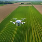
Agricultural Drones: Revolutionizing Farm Management
Industries that use drones are undergoing an extraordinary transformation, and agriculture is no exception. Cutting-edge drone technology has been introduced into various spheres of farming, marking a substantial advancement in drone uses for business in this sector.
The use of drones facilitates everything from crop monitoring, health assessment, and irrigation management, to pest detection and control. Not only has this innovation optimized productivity and yield, but it has also improved environmental sustainability, highlighting the significant drone benefit to agriculture.
Drone businesses, by offering a myriad of drone business opportunities, have become powerful allies for today’s tech-savvy farmers. They are now more than ever capable of making informed and timely decisions, thanks to diverse commercial uses for drones such as 3D mapping, crop dusting, and livestock tracking. These agricultural applications highlight the answer to the common query – what can drones be used for?
As a matter of fact, such drone business ideas have plowed the way to efficient farm management strategies, revolutionizing the way we perceive drones in industry. Therefore, it is clear that using drones stands at the heart of innovation within the agri-business sector, undeniably altering conventional farming practices for the better.
Delivery Drones: Redefining the Future of Parcel Service
In recent years, the landscape of parcel delivery has been dramatically transformed due to the invaluable uses of drones. Commercial drones, particularly delivery drones, are tech marvels simplifying logistics and supply chain networks.
Their role extends beyond just the delivery of parcels; they are increasingly being utilized for comprehensive tasks such as offshore delivery, urgent medical supply transport, and even food delivery, raising the bar for what are drones used for today. Companies like Harris Drone and other leading tech enterprises are ceaselessly innovating to adapt drones to various commercial practices, encapsulating how drones are used in the modern context.
Enterprise drones, primarily delivery drones, form the heart of the broad realm of drone applications. This unmanned aerial vehicle technology has unleashed a new era of efficiency and convenience in parcel service. The ability to bypass traditional road networks and directly commute to the destination paves the way for faster and more reliable deliveries.
Major corporations from all around the globe are capitalizing on the benefits that come with the use of a drone in delivery systems. Companies making drones focus on equipping these devices with advanced drone technology to cater to the escalating demands for commercial drones in industries.
High capacity, weather-resistant bodies, excellent navigation systems, and longer flight durations are just a few features that enhance drone capabilities in the field of parcel service delivery.
The following points encapsulate the growing importance and advantages of delivery drones in parcel service:
• Delivery drones offer a faster mode of transport by bypassing traditional road networks, thus ensuring timely deliveries.
• The use of these devices is not confined to just delivering parcels; they are also used for offshore delivery, urgent medical supply transport, and food delivery. This versatility has expanded their application scope beyond conventional boundaries.
• Major tech enterprises like Harris Drone are constantly innovating to adapt these unmanned aerial vehicles (UAVs) to various commercial practices. This shows how modern technology is being utilized in today’s world.
• Companies that manufacture drones focus on integrating advanced technologies into these devices to meet the increasing demand for commercial drones across industries.
• Features such as high capacity, weather-resistant bodies, excellent navigation systems, and longer flight durations enhance the capabilities of drones in parcel service delivery.
In conclusion, enterprise drones – primarily delivery drones – form an integral part of the broad realm of drone applications. By ushering in a new era of efficiency and convenience in parcel services, they have redefined what we know about logistics and supply chain networks.
The Critical Role of Drones in Search and Rescue Operations
Military drones, once solely used by the defense sector for surveillance and combat purposes, are now increasingly leading the charge in search and rescue operations. Their incorporation has the potential to accelerate response times during emergencies while significantly curtailing risks to human rescue teams.
The scope of search and rescue missions includes disaster relief, where drones can bridge the gap by providing crucial real-time information, mapping disaster-struck areas, and delivering essential supplies. In the same vein, their abilities of aerial photography and videography can play a monumental role in documenting the devastation, a vital tool for future disaster management planning.
Meanwhile, civilian drones which include personal and hobby drones, are broadening the base of Drone Technology’s role in society. Drones are now deployed in various sectors – Agriculture, for example, has significantly benefited from drone technology enabling detailed land surveying and better crop management.
Drone inspections have also been a game-changer in industries by providing safe, efficient, and cost-effective solutions. Ensuring security and surveillance functions, these drones have improved safety measures to an unprecedented level. As drone technology evolves, its capacity and effectiveness in diverse domains, particularly in the realm of search and rescue, are bound to further expand and innovate.
Photography and Drones: A New Dimension in Imaging
The intersection of drones and photography has significantly revolutionized numerous sectors including law enforcement, security, military operations, and wildlife monitoring. Drones, in essence, provide an aerial perspective that was once impossible or challenging to obtain, thus enriching photographic content and expanding the areas of application.
They have proven to be particularly useful in the military where they are enlisted for reconnaissance and surveying; these are some of the primary roles explaining what drones are used for in the military. Furthermore, drones play a pivotal role in modern construction projects, capturing detailed and precise images critical for site analysis, progression reports, and structural assessments, illustrating what drones are used for in construction.
In the realm of agriculture, drones fitted with cameras and sensors have come to the fore as an indispensable tool for precision farming. Not only do they capture high-resolution imagery but also collect data regarding crop health and soil moisture levels, presenting a clear picture of what drones are used for in agriculture.
The burgeoning e-commerce sector is capitalizing on the capabilities of drones for rapid and hassle-free delivery services. Their ability to bypass traffic and navigate with precision encapsulates what drones are used for in delivery.
Moreover, drones have also been instrumental in search and rescue operations, providing quick aerial surveys to locate missing individuals and deliver emergency supplies. Their utility in photographic documentation has also been employed in mapping and surveying tasks, contributing towards reliable and comprehensive data collection.
Surveying with Drones: A New Age of Precision and Efficiency
In alignment with prevalent industry needs, drones have taken center stage in various sectors for their proficiency and accuracy. Among the significant applications, drones have displayed remarkable potential in surveying procedures.
Their use in inspection tasks is especially noteworthy, providing an efficient mode of capturing high-resolution aerial images. This novel approach is proving invaluable in fields as diverse as firefighting, law enforcement, and security. Drones have delivered a new level of efficiency and safety in these areas, catalyzing coherent strategies and timely intervention.
Advancements in drone technology have fostered several stand-out features such as autonomous flight. This feature allows drones to conduct surveying tasks with minimum human intervention, essentially paving the way for a new level of precision.
However, operating these sophisticated devices requires specific knowledge and credentials, leading to a surge in Remote Pilot Certificate applications. From mapping terrain for industry needs and reforestation efforts to monitoring wildlife for conservation purposes, drones are making an impact.
They are also playing a pivotal role in crisis management, delivering emergency medical supplies via lightweight drones. Thus, drones are indisputably leading the charge in the evolution of multiple industries, endorsing a new era of effectiveness and precision.
Mapping the World: How Drones are Changing Cartography
In the realm of hardware manufacturing, multi-rotor and fixed-wing drones are being put to work for more robust global mapping solutions. Couples with advanced LiDAR systems, these robust drones have been instrumental in capturing high-resolution aerial photographs that are revitalizing the world of cartography to unseen levels.
From accurately mapping urban landscapes for city planning to surveying dangerous and difficult-to-access areas, there’s no denying that this technology is breathing life into new creative possibilities for mapping the world.
Beyond terrestrial mapping, underwater drones are also playing a significant part in marine cartography. For instance, they are being deployed to track underwater geographic features and monitor marine life. On land, agricultural drones are revolutionizing farm management with accurate mapping for precision agriculture.
They’re also used for livestock tracking, helping farmers monitor the location and behavior of their animals. Furthermore, drones have proved instrumental in anti-poaching operations by providing real-time, accurate tracking of wildlife poachers.
Still, we must acknowledge the cybersecurity risks that come with these advancements. Just like any other digital infrastructure, drones carrying what could be sensitive data, even donated organs, must be protected against hacking and misuse.
Drone Inspections: Boosting Efficiency and Safety in Industries
Unmanned aerial vehicles (UAVs), frequently referred to as drones, have demonstrated a significant contribution to the field of industrial inspections. Offering an eagle-eye view, these technological marvels efficiently conduct field surveys, providing precise data that enhance the operational safety and productivity of the industries.
Predominantly, fixed-wing drones equipped with high-grade photogrammetry and videography payloads have revolutionized inspections, eliminating the need for people to physically access potentially dangerous or hard-to-reach areas. Ground control stations (GCS) securely operate these infrastructural inspections, reaping the benefit of an increasingly digitized, safer, and cost-effective inspection process.
The X-37B UAV, amongst the pioneers in this relentless pursuit of advancement, embodies the epitome of autonomous delivery services. Utilizing this unpiloted aircraft has allowed for efficient package delivery to remote industrial sites, thereby reducing time and cost factors. Furthermore, using drones for land surveying has opened up new dimensions in precision and management.
Complying with licensing requirements for drone operations, industries are employing these vehicles to conduct photogrammetric mapping. This practice has exponentially boosted data accuracy, providing industries with well-defined and detailed topographical and structural information previously unattainable by conventional methods. Therefore, drone technology has taken a significant stride toward shaping the future of industrial safety and efficiency.
Firefighting Drones: A New Frontline in Fire Safety
As the advancements in drone technology continue to permeate various sectors, one area where their impact has been significantly transformative is in firefighting. Leveraging fixed-wing hybrid VTOL capabilities, firefighting drones bring an unprecedented level of efficiency to emergency response situations.
More than just a tool for combating flames, these sophisticated devices have proven instrumental in search and rescue missions, transporting essential supplies to remote, fire-engulfed locations, and providing real-time data to enable strategic firefighting maneuvers.
The cross-pollination of drone technology with reusable spacecraft technologies–originally intended for space travel experimentation–has provided insights that contribute vastly to the performance and reliability of firefighting drones. Furthermore, the adoption of secure delivery solutions commonly employed in drone delivery services ensures supplies are transported with minimal risk.
While the agricultural industry benefits from drone technology for precision farming, it also provides firefighting strategies with historical conservation practices, enhancing the preservation of arable lands in rural fire incidents. The same drone technology, once exclusive to military operations, has thus proven itself a formidable force on a new frontline: fire safety.
Law Enforcement and Drones: A New Tool for Justice
The proliferation of drone technology in law enforcement has marked the ushering of a new era of justice and safety. While single-rotor helicopters were once the gold standard in aerial policing, the use of propeller-propelled drones brings a unique blend of navigation capabilities and safety enhancements.
Equipped with high-definition cameras and data links, these drones enable real-time surveillance and transmission of high-definition videos to control centers. Hybrid drones, with added endurance and range, further elevate their application in extensive operations.
However, as this technology is being adopted, several challenges and privacy concerns arise. The operation of drones demands a thorough understanding of airspace issues and aeronautical knowledge. Law enforcement agencies must ensure their drone operators pass an aeronautical knowledge test, focusing on flight measurements and operations in various climatic conditions.
Moreover, the potential of drones in building 3D models and deploying 3D modeling techniques for crime scene investigation is under scrutiny due to privacy implications. Balancing the advantages of drones with the associated privacy concerns is an ongoing discourse, indicating a need for stringent regulations and clear use policies.
Security Drones: A Novel Approach to Surveillance and Protection.
In recent years, the security sector has seen a revolutionary advance with the adoption of drone technology. Drone pilots are now a vital part of many security agencies, providing an edge to the surveillance and protection modules. The invaluable perspective offered by these flying entities, in combination with the adept skills of drone pilots, can strengthen security paradigms, be it for event security, crowd management, or property protection.
Drone technology has also surprisingly found its application in agricultural surveillance. Particularly, crop yield estimation, a task traditionally seen as demanding and labor-intensive, has been significantly simplified with the introduction of drones.
They provide accurate overhead imagery and data, permitting farmers to get a comprehensive view of their fields, and consequently, make informed decisions. These high-tech marvels are thus reshaping many sectors, transcending boundaries of what was once deemed possible.
What are security drones?
Security drones are unmanned aerial vehicles (UAVs) equipped with high-resolution cameras and other technology to monitor and protect areas from potential threats or nefarious activities.
How does drone technology work?
Drone technology works on the principles of aerial robotics, navigation, real-time image processing, and data analytics. They are remote-controlled or programmed to fly autonomously using embedded sensors and GPS.
How are drones used in the military?
In the military, drones are used for a number of reasons such as surveillance, reconnaissance, target acquisition, and in some cases, to carry out airstrikes. They provide real-time images and data, reducing risks to human life.
What is the role of drones in construction projects?
Drones play a significant role in construction projects by providing aerial views for site inspection, monitoring work progress, assessing project risks, mapping and surveying the area, and ensuring worker’s safety.
How are drones revolutionizing farm management?
Drones are revolutionizing farm management by enabling precision agriculture. They are used for soil analysis, crop monitoring, spraying pesticides, irrigation, planting, and yield estimation.
How are delivery drones redefining parcel service?
Delivery drones are redefining parcel service by providing faster, more efficient, and eco-friendly options for delivering small packages, especially in remote or hard-to-reach areas.
What is the role of drones in search and rescue operations?
Drones play a critical role in search and rescue operations by providing real-time aerial footage, locating missing persons, delivering supplies, and enabling safer and quicker responses.
How are drones used in photography?
Drones in photography offer a unique perspective by capturing high-resolution aerial shots, panoramas, and 360-degree images, opening up new dimensions in imaging.
How does drone surveying work?
Drone surveying involves using drones to capture aerial images and data, which are then processed into 3D models or maps, offering a highly accurate and efficient method of surveying.
How are drones used in industrial inspections?
Drones are used in industrial inspections to safely and efficiently assess the condition of infrastructure, equipment, and facilities, often in hard-to-reach places, reducing risks and costs.
How are drones used in firefighting?
Firefighting drones are used to monitor and assess fire situations, provide real-time footage, locate victims, and even deliver firefighting equipment, enhancing safety and efficiency.
How are drones used for law enforcement purposes?
Law enforcement agencies use drones for surveillance, crime scene analysis, traffic monitoring, crowd control, search and rescue missions, and gathering evidence.
How does the use of drones enhance security and protection measures?
Drones enhance security and protection measures by providing real-time monitoring and surveillance, rapid response to incidents, evidence gathering, and safer and more efficient operations.